
Le Riserve Naturali dei Monti Iblei - Promozione Turistica Escursionistica

in italiano
Cava Ispica è una vallata fluviale che per 13 km incide l'altopiano ibleo, tra le città di Modica e Ispica. La vallata, immersa nella tipica vegetazione della macchia mediterranea, custodisce necropoli preistoriche, catacombe cristiane, oratori rupestri, eremi monastici e nuclei abitativi di tipologia varia. Nell'area terminale della vallata nel territorio di Ispica, a ridosso della città, numerose sono le testimonianze che attestano la presenza dell'uomo dalla preistoria sino al terremoto del 1693.
In Inglese
Cava Ispica is a river valley for 13km affects the Hyblean plateau, between the towns of Modica and Ispica . The valley, surrounded by the typical Mediterranean vegetation, preserves prehistoric burial sites, Christian catacombs, rocky oratories, hermitages and monasteries residential units of various types. In the valley terminal in Ispica territory, near the city, there are many testimonies that prove the presence of man from prehistoric times until the 1693 earthquake.
|
|

In Italiano
Pantalica, o meglio la Necropoli Rupestre di Pantalica, è una località naturalistico-archeologica della provincia di Siracusa. Il nome del sito sembra derivare dall'arabo Buntarigah, che significa grotte, per l'ovvia presenza di molteplici grotte naturali e artificiali. Costituisce uno dei più importanti luoghi protostorici siciliani, utile per comprendere il momento di passaggio dall'età del bronzo all'età del ferro nell'isola. Nel 2005 il sito è stato insignito, insieme con la città di Siracusa, del titolo di Patrimonio dell'umanità da parte dell'UNESCO per l'alto profilo storico, archeologico, speleologico e paesaggistico. La località di Pantalica ha dato il nome a un celebre racconto di Vincenzo Consolo, Le pietre di Pantalica , in cui l'altopiano diventa una metafora del cammino dell'uomo.
In Inglese
Pantalica, or rather the Rock Necropolis of Pantalica is a natural and archaeological localities of the province of Syracuse. The site name seems to derive from the Arabic Buntarigah, which means caves, for the obvious presence of several natural and artificial caves. It constitutes one of the most important prehistoric sites in Sicily, useful to understand the moment of transition from the Bronze Age to the Iron Age in the island. In 2005 the site was awarded, along with the city of Syracuse, the title of World Heritage Site by UNESCO for its high historical, archaeological, caving and landscape. The town of Pantalica has given its name to a famous story by Vincenzo Consolo, The Pantalica stones, where the plateau becomes a metaphor of human life.
|
|
|

|
|
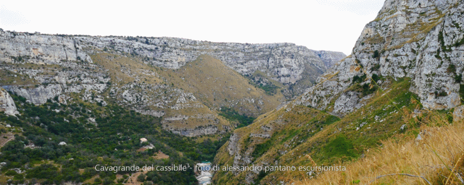
La Riserva naturale orientata Cavagrande del Cassibile è compresa nei comuni di Avola, Noto e Siracusa, in provincia di Siracusa, in Sicilia. È stata istituita nel 1990 (D.A. del 13 luglio), gestita dall'Azienda Foreste Demaniali della Regione Siciliana; ne è prevista l'inclusione nell'area del Parco Nazionale degli Iblei, attualmente in fase di elaborazione. La Riserva è nata con lo scopo di preservare le diverse ricchezze del suo territorio sia dal punto di vista naturalistico-paesaggistico sia sotto il profilo archeologico ed antropologico, visto che tutta la zona è stata abitata nel corso dei millenni e ne sono rimaste notevoli testimonianze in tombe e reperti. La Riserva si estende per 2700,00 ettari, 900 ha nella zona A (riserva) e 1860,00 ha nella zona B (preriserva) ed è caratterizzata dal corso del fiume Cassibile, l'antico Kakyparis greco, che le dà nome e che l'ha creata nel corso dei millenni scavando profonde gole o canyon a diverse profondità che toccano il massimo di 507 m nella zona belvedere di Avola antica; anche il luogo con l'ampiezza massima di queste (altrove strettissime) gole è situato nella stessa zona di Avola antica e misura un'estensione di 1200 metri di larghezza. Nel fondovalle, si è formato un sistema di piccole cascate e laghetti (chiamati localmente uruvi) fonti di refrigerio estivo per i suoi numerosissimi frequentatori ai quali si accede per un'antica suggestiva scala nota come La Scala Cruci.
The nature reserve Cavagrande is included in the municipalities of Avola, Noto and Syracuse, in the province of Siracusa, Sicily. It was established in 1990 (D.A. of 13 July), managed by the Forestry Authority of the Region of Sicily; It is exclusively for the inclusion in the National Park Iblei, currently being drafted. The reserve was created with the aim of preserving the diverse wealth of its territory both in terms of nature and landscape views from both the archaeological and anthropological profile, since the whole area has been inhabited over the millennia, and it is rich in testimony were in tombs and artifacts. The Reserve covers 2700,00 ha, 900 ha in the area A (reserve) and 1860.00 has in the area B (preriserva) and is characterized by the course of the river Cassibile, the ancient greek Kakyparis, which gives her name and that He has created over thousands of years by digging deep gorges and canyons at different depths which touch the maximum of 507 m in the old lookout area of Avola; also the place with the maximum amplitude of these (elsewhere tight) gorge is located in the same ancient area of Avola and extent an extension of 1200 meters wide. In the valley, it has formed a system of small waterfalls and ponds (locally called uruvi) summer refreshment sources for its numerous visitors which are accessed by an ancient suggestive scale known as La Scala Cruci.
The nature reserve Cavagrande is included in the municipalities of Avola, Noto and Syracuse, in the province of Siracusa, Sicily. It was established in 1990 (D.A. of 13 July), managed by the Forestry Authority of the Region of Sicily; It is exclusively for the inclusion in the National Park Iblei, currently being drafted. The reserve was created with the aim of preserving the diverse wealth of its territory both in terms of nature and landscape views from both the archaeological and anthropological profile, since the whole area has been inhabited over the millennia, and it is rich in testimony were in tombs and artifacts. The Reserve covers 2700,00 ha, 900 ha in the area A (reserve) and 1860.00 has in the area B (preriserva) and is characterized by the course of the river Cassibile, the ancient greek Kakyparis, which gives her name and that He has created over thousands of years by digging deep gorges and canyons at different depths which touch the maximum of 507 m in the old lookout area of Avola; also the place with the maximum amplitude of these (elsewhere tight) gorge is located in the same ancient area of Avola and extent an extension of 1200 meters wide. In the valley, it has formed a system of small waterfalls and ponds (locally called uruvi) summer refreshment sources for its numerous visitors which are accessed by an ancient suggestive scale known as La Scala Cruci.
|
|
|

Copyright ©2016 by alessandro pantano. Tutto il materiale presente in quest'opera
è soggetto a Copyright. La riproduzione parziale o totale di esso è perseguibile dalla legge.
è soggetto a Copyright. La riproduzione parziale o totale di esso è perseguibile dalla legge.
